The Copernicus
Climate Change Service (C3S), implemented by the European Centre for
Medium-Range Weather Forecasts on behalf of the European Commission with
funding from the EU, routinely publishes monthly climate bulletins reporting on
the changes observed in global surface air and sea temperatures, sea ice cover
and hydrological variables. Additionally, the bulletin also includes highlights
regarding the boreal spring (March-April-May). Most of the reported findings
are based on the ERA5 reanalysis dataset, using billions of measurements from
satellites, ships, aircraft and weather stations around the world.

June
2024—Surface air temperature and sea surface temperature highlights:
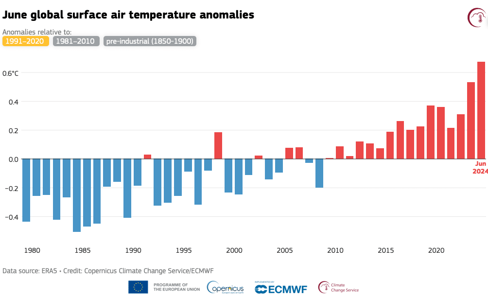
- June 2024 was warmer globally than any previous June in the data record, with an average ERA5 surface air temperature of 16.66°C, 0.67°C above the 1991-2020 average for June and 0.14°C above the previous high set in June 2023.
- This is the thirteenth month in a row that is the warmest in the ERA5 data record for the respective month of the year. While unusual, a similar streak of monthly global temperature records happened previously in 2015/2016.
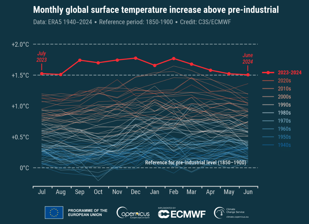
- According to ERA5 data, the month was 1.50°C above the estimated June average for 1850-1900, the designated pre-industrial reference period, making it the twelfth consecutive month to reach or break the 1.5°C threshold.
- The global-average temperature for the past 12 months (July 2023—June 2024) is the highest on record, at 0.76°C above the 1991-2020 average and 1.64°C above the 1850-1900 pre-industrial average.
- The average European temperature for June 2024 was 1.57°C above the 1991-2020 average for June, making the month the joint-second warmest June on record for Europe.
- European temperatures were most above average over southeast regions and Türkiye, but near or below average over western Europe, Iceland and northwestern Russia.
- Outside Europe, temperatures were most above average over eastern Canada, the western United States and Mexico, Brazil, northern Siberia, the Middle East, northern Africa and western Antarctica.
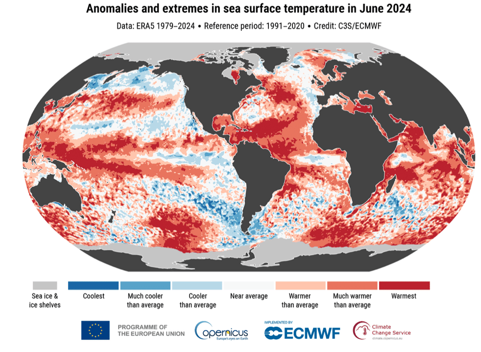
- Temperatures were below average over the eastern equatorial Pacific, indicating a developing La Niña, but air temperatures over the ocean remained at an unusually high level over many regions.
- The sea surface temperature (SST) averaged for June 2024 over 60°S—60°N was 20.85°C, the highest value on record for the month.
- This is the fifteenth month in a row that the SST has been the warmest in the ERA5 data record for the respective month of the year.
- Datasets other than ERA5 may not confirm the 12-month streak highlighted here, due to the relatively small margins above 1.5°C of ERA5 global temperatures for July and August 2023, May and June 2024, and differences among the various datasets. Also, it must be stressed that the 1.5°C and 2°C limits set in the Paris Agreement are targets for the average temperature of the planet over a twenty or thirty-year period.

Monthly
global surface air temperature anomalies (°C) relative to 1850—1900 from
January 1940 to June 2024, plotted as time series for all 12-month periods
spanning July to June of the following year. The 12 months from July 2023 to
June 2024 are shown with a thick red line, while all other 12-month periods are
shown with thin lines shaded according to the decade, from blue (1940s) to
brick red (2020s). Data source: ERA5. (Photo: Copernicus Climate Change Service
/ECMWF)
According to
Carlo Buontempo, Director of the Copernicus Climate Change Service (C3S):
“June marks the
13th consecutive month of record-breaking global temperatures, and the 12th in
a row above 1.5°C with respect to pre-industrial. This is more than a
statistical oddity and it highlights a large and continuing shift in our
climate. Even if this specific streak of extremes ends at some point, we are
bound to see new records being broken as the climate continues to warm. This is
inevitable, unless we stop adding GHG into the atmosphere and the oceans.”

Global-mean surface air temperature anomalies relative to 1991-2020 for
each June from 1979 to 2024. Data source: ERA5. (Photo: Copernicus
Climate Change Service/ECMWF)
June
2024—Hydrological highlights
- June 2024 was wetter than average over Iceland, central and most of south-western Europe, with heavy precipitation leading to floods in regions of Germany, Italy, France and Switzerland.
- The month was drier than average over Ireland, most of the UK, Fennoscandia, southern Italy and much of Eastern Europe, particularly around the Black Sea.
- Outside Europe, in June 2024, it was wetter than average over parts of North America, with a series of storms, including exceptional Hurricane Beryl. It was wetter than average also over south-western and south-eastern Asia, southernmost Africa, regions of Australia and South America.
- Drier-than-average conditions were seen across North America, several regions of Asia and most of South America. Severe wildfires occurred in northeastern Russia and central South America.
June 2024—Sea
Ice highlights
- Arctic sea ice extent was 3% below average, close to the values observed most years since 2010.
- Antarctic sea ice extent was 12% below average, the second-lowest extent for June in the satellite data record, behind the lowest June value of -16% observed in 2023.

Anomalies and extremes in sea surface temperature for June 2024. Colour
categories refer to the percentiles of the temperature distributions for
the 1991—2020 reference period. The extreme (“Coolest” and “Warmest”)
categories are based on rankings for the period 1979—2024. Values are
calculated only for the ice-free oceans. Areas covered with sea ice and
ice shelves in June 2024 are shown in light grey. Data source: ERA5.
(Photo: Copernicus Climate Change Service/ECMWF)

No comments:
Post a Comment